Minecraft version
Back to mods 
CurseForge · Minecraft mod
Topographic Maps 3D
Transform Minecraft's vanilla maps into detailed topographic maps, adding elevation data and contour lines directly to the existing mapping system
Choose a version Pick your version below, then grab the matching file.
Quick answer
Which Topographic Maps 3D release should I use?
Latest stable file topographic-maps-0.3.1+mc1.21.jar
Game version 1.21
Loader Fabric
Topographic Maps 3D topographic-maps-0.3.1+mc1.21.jar targets 1.21 with Fabric. The project page does not say whether this file belongs on the client, dedicated server, or both. No extra mods listed for this file.
Where it goes
Is Topographic Maps 3D required on the client, server, or both?
The project page does not say whether this file belongs on the client, dedicated server, or both.
Client Source doesn’t say
Dedicated server Source doesn’t say
Loader for this release Fabric
Required install it here Optional supported, not mandatory Not supported do not install here Source doesn’t say do not assume
The source does not explicitly classify this release as client-only or server-only.
What else does Topographic Maps 3D topographic-maps-0.3.1+mc1.21.jar need?
topographic-maps-0.3.1+mc1.21.jar. Change the file and its required mods may change too.
This file does not list any required mods. Do not add a library just because a different file uses it.
This file does not list any required or optional mods.
Before you install it
Add Topographic Maps 3D without breaking your instance.
Built for Topographic Maps 3D topographic-maps-0.3.1+mc1.21.jar. Pick another file and the loader, install side or required mods may change.
- 01
Stick to this file
Use topographic-maps-0.3.1+mc1.21.jar. It targets 1.21 with Fabric; another release may have different loader, side or dependency requirements.
- 02
Bring the mods it needs
This file does not list any required mods. Do not add a library just because a different file uses it.
- 03
Put it on the correct side
The project page does not say whether this file belongs on the client, dedicated server, or both.
- 04
Pick the file you checked
Use the “Get this file” button beside topographic-maps-0.3.1+mc1.21.jar. It opens that exact file at the source.
About this project
What does Topographic Maps 3D add?
Topographic Maps
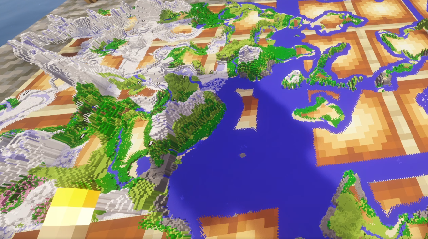
Put a filled map in an item frame and it stops being a picture of the land and becomes the land — raised into a solid model built out of blocks, wearing the map's own colours.
That is the whole mod. There is no new item, no new recipe, nothing to learn. You craft a map, fill it in and hang it up exactly as you always have. It just stands up now.
What it does
- The mod records the actual elevation under your map and builds a model from it. Hills rise, valleys sink, cliffs read as cliffs.
- Built out of blocks. The land is made of square columns with flat tops and sheer sides — the same shape a stack of blocks makes, which is what it is modelling. Nothing is smoothed or stretched, so every pixel of the map is drawn at its own size wherever it lands.
- Mountains actually stand taller. Height is measured on one fixed scale shared by every map, so a mountain range visibly out-rises a map of rolling farmland — and the same elevation stands the same height on every map you own.
- It is still your map. The model is skinned with the map's own colours, so it matches the flat map pixel for pixel - the same map, standing up.
- Fills in as you explore. Elevation is recorded alongside the map's colours, at the same pace, so terrain appears exactly where the map has something to show.
- Keeps up with the world. Flatten a hill or dig a canyon and the map catches up on its own.
- Map walls line up. Neighbouring maps agree on the ground they share, so a grid of them reads as one continuous landscape rather than a set of tiles.
Distant Horizons
Optional, and detected automatically - if you do not have it, nothing about the mod changes.
Elevation normally comes from loaded chunks, which is the right rule while a map is filling in but leaves an already explored map flat forever: by the time it is on your wall, the ground it shows is long unloaded and there is nothing left to measure.
With Distant Horizons installed, the mod falls back to its record of terrain you have already seen, so old maps stand up on their own. It is only ever used for ground nothing else can read, and the moment you walk that terrain again the exact measurement replaces it.
One caveat worth knowing: Distant Horizons only knows what it has itself seen or generated. If you explored those maps before installing it, its record is empty too, and the terrain appears once it has generated that area.
Controls
- N - show or hide the relief, leaving the ordinary flat map underneath. Rebindable in Controls, under Miscellaneous.
- A progress bar appears above the hotbar while a map is building, so a map that is merely still filling in is easy to tell from one that has nothing to show.
How to use it
- Craft and fill a map the normal way.
- Place it in an item frame.
- Look at it from an angle - that is where the relief reads best.
Maps already hanging on a wall are picked up too. Stand near them and they fill in by themselves; you do not have to take anything down.
Needed on both sides: the server records the elevation, the client draws it.
Performance
The model is worked out once per map and rebuilt only when the terrain actually changes, so a finished map on a wall costs nothing to keep looking at - drawing it is pure copying, with no decisions taken per frame.
Neighbouring ground standing at the same height is merged into single large surfaces rather than drawn column by column, which on flat country such as ocean or plains is the difference between thousands of pieces and a handful. The hidden half of every surface is discarded as well, so what reaches the graphics card is roughly half of what is there.
On the world side, elevation is only recorded for maps someone is holding or standing near, only from chunks that are already loaded, and a finished map drops out of the sweep entirely. The mod never forces terrain to generate.
Feedback and bug reports are genuinely useful at this stage - it is an early release and the rough edges are known ones.
Do you want a cheap and secure hosting?

Project description from CurseForge.
Pick your setup
Topographic Maps 3D by Minecraft version and loader
Choose the version and loader you play, then open the matching release.
Minecraft version
1.21.10
1 loader buildMinecraft version
1.21.9
1 loader buildMinecraft version
1.21.8
1 loader buildMinecraft version
1.21.7
1 loader buildMinecraft version
1.21.6
1 loader buildMinecraft version
1.21.5
1 loader buildMinecraft version
1.21.4
1 loader buildMinecraft version
1.21.3
1 loader buildMinecraft version
1.21.2
1 loader buildMinecraft version
1.21.1
1 loader buildMinecraft version
1.21
1 loader buildCheck the dependencies, then try the file in a copied instance before changing a world you care about.
Recent files
Topographic Maps 3D versions and loaders
topographic-maps-0.3.1+mc1.21.jar
8 Sept 2026
Client Source doesn’t say Server Source doesn’t say Dependencies No extras listed Listed on Release listing
Check the 1.21 · Fabric setup 1.21Fabric release
topographic-maps-0.3.1+mc1.21.11.jar
8 Sept 2026
Client Source doesn’t say Server Source doesn’t say Dependencies No extras listed Listed on Release listing
Check the 1.21.11 · Fabric setup Fabric1.21.11 release
topographic-maps-0.3.1+mc1.21.10.jar
8 Sept 2026
Client Source doesn’t say Server Source doesn’t say Dependencies No extras listed Listed on Release listing
Check the 1.21.10 · Fabric setup Fabric1.21.10 release
topographic-maps-0.3.1+mc1.21.9.jar
8 Sept 2026
Client Source doesn’t say Server Source doesn’t say Dependencies No extras listed Listed on Release listing
Check the 1.21.9 · Fabric setup Fabric1.21.9 release
topographic-maps-0.3.1+mc1.21.8.jar
8 Sept 2026
Client Source doesn’t say Server Source doesn’t say Dependencies No extras listed Listed on Release listing
Check the 1.21.8 · Fabric setup Fabric1.21.8 release
topographic-maps-0.3.1+mc1.21.7.jar
8 Sept 2026
Client Source doesn’t say Server Source doesn’t say Dependencies No extras listed Listed on Release listing
Check the 1.21.7 · Fabric setup Fabric1.21.7 release
topographic-maps-0.3.1+mc1.21.6.jar
8 Sept 2026
Client Source doesn’t say Server Source doesn’t say Dependencies No extras listed Listed on Release listing
Check the 1.21.6 · Fabric setup Fabric1.21.6 release
topographic-maps-0.3.1+mc1.21.5.jar
8 Sept 2026
Client Source doesn’t say Server Source doesn’t say Dependencies No extras listed Listed on Release listing
Check the 1.21.5 · Fabric setup Fabric1.21.5 release
topographic-maps-0.3.1+mc1.21.4.jar
8 Sept 2026
Client Source doesn’t say Server Source doesn’t say Dependencies No extras listed Listed on Release listing
Check the 1.21.4 · Fabric setup Fabric1.21.4 release
topographic-maps-0.3.1+mc1.21.3.jar
8 Sept 2026
Client Source doesn’t say Server Source doesn’t say Dependencies No extras listed Listed on Release listing
Check the 1.21.3 · Fabric setup Fabric1.21.3 release
topographic-maps-0.3.1+mc1.21.2.jar
8 Sept 2026
Client Source doesn’t say Server Source doesn’t say Dependencies No extras listed Listed on Release listing
Check the 1.21.2 · Fabric setup Fabric1.21.2 release
topographic-maps-0.3.1+mc1.21.1.jar
8 Sept 2026
Client Source doesn’t say Server Source doesn’t say Dependencies No extras listed Listed on Release listing
Check the 1.21.1 · Fabric setup Fabric1.21.1 release
Looking for an older file? The official CurseForge project page is in Resources.